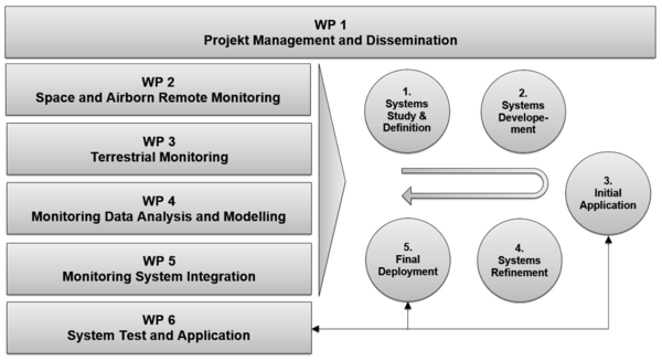
Project Objectives
i²MON (Integrated Mining Impact Monitoring) is dedicated to deliver the mining sector, government, citizens and all stakeholders affected by previous and current mining activity with a set of extended monitoring, measurement and analysis tools for identification of mining impact related to ground and slope movements and support with essential information concerning the ground surface condition at mining and post mining areas. The main objectives are:
- Development of innovative monitoring tools for enhanced ground and slope deformation monitoring using advanced terrestrial (low-cost geodetical, geotechnical sensors), laser technology, spaceborne (Sentinel, TerraSAR-X PSI) and airborne (UAV) technology delivering continuous, near real time data acquisition and extensive areal information.
- Identification of physical processes that affect ground and slope deformations and development of suitable modelling methods to be implemented in order to make reliable impact predictions. Modelling information is foreseen to be directly integrated with the monitoring information to substantially improve the temporal and spatial information density and result exploitation.
- Development of the integrated monitoring system, including data ports, database, analysis and visualization functionalities aiming to substantially reduce the cost of information and enable a quantitative risk assessment of mining impact and precise identification of sites carrying the highest liability.
- The research consortium aims to establish a complete integrated monitoring and analysis service regarding ground and slope deformation for the coal mining community.


Project Management and Dissemination
read more »This includes:
- Overall technical coordination and formalization of the joint research structure
- Organisation and management of project meetings
- Distribution of technical data and information exchange among partners including a data exchange server
- Follow up on delivery deadlines and timely delivery of the project deliverables and research schedule
- Meetings minutes preparation, Integration of project reports and presentations
- Management of administrative issues and relation with EC
- Dissemination work including design, implementation and maintenance of the project website and creation of public project information material and professional social networks (e.g. LinkedIn)
- Knowledge transfer including integration of results in the MSc module Geomonitoring at TUBAF
Download the i2MON User Workshop presentation: 1_i2MON Intro_Zimmermann.pdf

Space and Airborne Remote Monitoring
read more »This includes:
- Study on suitable sensor technology including advanced satellite radar, airborne radar, laser and optical data sources. This includes the evaluation of available carrier systems as satellite, aircraft or UAV.
- Development of Monitoring Data Acquisition and Processing Systems
- UAV measurement flights for laser data acquisition at open pit site and data processing
- The development process will have the following steps: initial system development and setup, system test, final optimized development, final application
Download the i2MON User Workshop presentation: 2_InSAR_Chia_Lubitz.pdf & 3_UAV LiDAR_Petrini.pdf

Terrestrial Monitoring
read more »This includes:
- Research on enhanced ground and slope motion monitoring using advanced terrestrial sensors as low-cost geodetical, geotechnical sensors
- Development of an advanced monitoring system based on low cost sensors technology (geodetical, geophysical, geotechnical equipment). The development includes innovative automated communication technology (ICT) for automated sensor data transfer.
- The development process will have the following steps: initial system development and setup, system test, final optimized development, final application
Download the i2MON User Workshop presentation: 4_GB Lidar_Becker_Schröder.pdf

Monitoring Data Analysis and Modelling
read more »The WP includes:
- Research on suitable modelling (ground and slope deformations) and data analysis (deformation and change detection) technologies
- Development of advanced modelling techniques for ground and slope deformation
- Development of advanced data mining, analysis and change detection methods
- The development processes will have the following steps: initial model and tool development and setup, test, final optimized development, final application
Download the i2MON User Workshop presentation: 5_Slope Stability Modelling_Mohsan.pdf & 6_Ground Subsidence Modelling_Tajdus.pdf
Monitoring System Integration
read more »This includes the development of an integrated monitoring system, including data ports, database, analysis and visualization functionalities aiming to enable a quantitative risk assessment of mining impact and precise identification of locations carrying the highest liability. The system will serve to prepare the industrial partners for the use of the system and improve the efficiency and effectiveness of the use of monitoring data in operational environment. The WP includes:
- Development of an integrated monitoring system – system design, setup
- Definition of interfaces and ports for relevant project data
- The development process will have the following steps: initial system development and setup, system test, final optimized development, final application
Download the i2MON User Workshop presentation: 7_Sensor Data Platform_Zimmermann.pdf

Monitoring System Application
read more »This includes:
- Selection and description of the test sites – underground mining, open pit mining
- Gathering of available reference data such geotechnical parameters, geological information, existing monitoring data
- Initial technology application at test sites – technology from WP2, WP3, WP4 and WP5
- Final application of optimized methods at test site – technology from WP2, WP3, WP4 and WP5
- Evaluation of results from industrial standpoint